 |
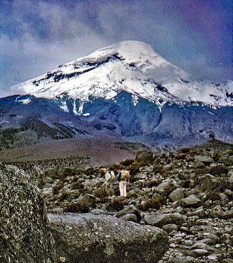
| Bob and John as we contemplated started off on our climb of Chimborazo Volcano |
 |
| View of the volcano as we began our climb |
The peak of the volcano is 6,263 meters (20,548 ft) above sea level. Chimborazo’s summit is also the farthest point on the Earth’s surface from the planet’s center, being located along the equatorial bulge. The bulge makes the planet about 43 km (27 mi) wider at the equator than pole-to-pole.
Chimborazo is a favorite of mountain climbers. Reaching the top of the volcano is not a stroll in the country. The climb requires some skill and is often on black ice with low visability due to the clouds crowning its summit. Clampons and other climbing equipment are required.
Reading my trip description in the letter excerpt below, I am struck by my naivety regarding the potential climb difficulties. I certainly did not possess the technical equipment which would minimize the dangers associated with a transverse of the icy glacier surface at the volcano's summit. Remaining at the refuge below the snowline was perhaps a smarter decision than I realized at the time.
 |
| Settling a disagreement |
The quality of developed photos prior to digital was sometimes hit or miss. However, I doubt that so many of mine turned out as duds upon development. I fear that many were misplaced and lost over the intervening years.
Cayambe and Sundry

Cayambe mountain and farmland

 The
above photo gives a clear picture of the agriculture system in
Ecuador's highlands. The higher and steeper lands beneath the rocky
height are generally all that is left for the indians to cultivate.
These snippets from an April letter give some sense of the variety of my Peace Corps service life in the capital city of Ecuador. The architecture exhibition was unusual, but we frequently attended first run movies at the local cinema.

The
above photo gives a clear picture of the agriculture system in
Ecuador's highlands. The higher and steeper lands beneath the rocky
height are generally all that is left for the indians to cultivate.
The second paragraph indicates a bit of the variety of co-op activity I was involved with in Quito. The seminar preparation and statistical report were probably worked on in the National Credit Union Federation building. Working with individual co-ops usually occured in their place of business.
The trip to Cayambe was with the Ecuadorian extention agent with whom I frequently worked. The co-ops are located in the zone of the country which was our responsibility. The last paragraph gives a sense of my thoughts on some of the difficulties we faced in helping the people of the country achieve economic and social success.
Cotocollao: Prejudice and Progress
The prejudice toward the indian population of Ecuador is well illustrated by the conflicts among the residents of Cotocollao's barrios. The evil of such prejudice is made extremely graphic by the example of the indian woman trying to get a bus ride to Quito.
Ancient Cotocollao was a large village. Prior to the discovery of the archaeological site in the 1970s, little was known about pre-columbian cultural life in the northern sierra. The site is strategically located near a pass that connects the Quito basin with the tropical forests
of the western Andean foothills. Cotocollao was occupied from
approximately 1800 to 500 bce. The occupation levels at
Cotocollao are capped by a thick layer of volcanic ash and lapilli
associated with the eruption of Mount Pululahua, which is located about
seventeen miles to the north. The eruption of this volcano, dated to
approximately 467 bce, is thought to have caused the abandonment of the
site.


No comments:
Post a Comment