Showing posts with label cooperative education. Show all posts

Tuesday, March 9, 2021

Chimborazo


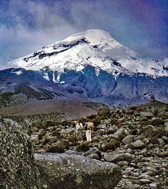
Bob and John as we contemplated started off on our climb of Chimborazo Volcano
 

View of the volcano as we began our climb
Chimborazo is the highest mountain in Ecuador and in the Andes north of Peru.
Despite its great height, it is only the 39th highest peak in the Andes. These mountains stretch from the Caribbean Coast of Columbia to the Strait of Magellan in the southern reaches of Chile. Chimborazo is a currently inactive stratovolcano in the Cordillera Occidental range of the Andes. Its last known eruption is believed to have occurred around 550 CE.
 
Climbing through a boulder field
 
The peak of the volcano is 6,263 meters (20,548 ft) above sea level.  Chimborazo’s summit is also the farthest point on the Earth’s surface from the planet’s center, being located along the equatorial bulge. The bulge makes the planet about 43 km (27 mi) wider at the equator than pole-to-pole.

Chimborazo is a favorite of mountain climbers. Reaching the top of the volcano is not a stroll in the country. The climb requires some skill and is often on black ice with low visability due to the clouds crowning its summit. Clampons and other  climbing equipment are required. 

Reading my trip description in the letter excerpt below, I am struck by my naivety regarding the potential climb difficulties. I certainly did not possess the technical equipment which would minimize the dangers associated with a transverse of the icy glacier surface at the volcano's summit. Remaining at the refuge below the snowline was perhaps a smarter decision than I realized at the time.
 
Settling a disagreement
One major disappointment became more evident as I read this letter and searched my files. Numerous photos from my Peace Corps days were missing from the archive I had saved over the years.  The unusual photos and magnificant vistas that i mentioned in this letter were nowheres to be found. 
 
The quality of developed photos prior to digital was sometimes hit or miss. However, I doubt that so many of mine turned out as duds upon development. I fear that many  were misplaced and lost over the intervening years. 


Cayambe and Sundry


Cayambe mountain and farmland


The above photo gives a clear picture of the agriculture system in Ecuador's highlands. The higher and steeper lands beneath the rocky height are generally all that is left for the indians to cultivate.

These snippets from an April letter give some sense of the variety of my Peace Corps service life in the capital city of Ecuador. The architecture exhibition was unusual, but we frequently attended first run movies at the local cinema. 

The second paragraph indicates a bit of the variety of co-op activity I was involved with in Quito.  The seminar preparation and statistical report were probably worked on in the National Credit Union Federation building. Working with individual co-ops usually occured in their place of business.

The trip to Cayambe was with the Ecuadorian extention agent with whom I frequently worked. The co-ops are located in the zone of the country which was our responsibility.  The last paragraph gives a sense of my thoughts on some of the difficulties we faced in helping the people of the country achieve economic and social success.


Cotocollao: Prejudice and Progress


The prejudice toward the indian population of Ecuador is well illustrated by the conflicts among the residents of Cotocollao's barrios. The evil of such prejudice is made extremely graphic by the example of the indian woman trying to get a bus ride to Quito. 
 
Ancient Cotocollao was  a large village. Prior to the discovery of the archaeological site in the 1970s, little was known about pre-columbian cultural life in the northern sierra. The site is strategically located near a pass that connects the Quito basin with the tropical forests of the western Andean foothills. Cotocollao was occupied from approximately 1800 to 500 bce. The occupation levels at Cotocollao are capped by a thick layer of volcanic ash and lapilli associated with the eruption of Mount Pululahua, which is located about seventeen miles to the north. The eruption of this volcano, dated to approximately 467 bce, is thought to have caused the abandonment of the site.

Sunday, February 21, 2021

Ambato, Baños and Surprises


Recent photo of Ambato's city center


Ambato

 
Ambato is 2.5 hours by bus and 160 kilometers south of Quito. As is Quito, it is a city located in the central Andean valley of Ecuador. With a population of over 300,000, it is the capital of the province of Tungurahua, and situated at an elevation of 2,577 meters above sea level.  
 
Washing clothes along the river in Latacunga
A visitor is struck by the distinct difference in urban appearence between Quito and Ambato. A search for a historical center will come up empty in the latter city. To understand the difference, one must look to history.
 
On August  5, 1949, the Ambato was struck by a devastating earthquake. According to Wikipedia, it is estimated that more than six thousand people died, and thousands more were left homeless and destitute by the disaster.
 
Much of the city's colonial center was completely ruined. The city was rebuilt with significant international help. The Fruit and Flower Festival is held every year in Ambato to commemorate the anniversary of the earthquake.
 
Latacunga where the clothes are being washed is a town on the Panamerican Highway between Ambato and Quito. I remember taking the photo from the bus window. The photo below adjoining my letter is my only surviving image of the Fruit and Flower Festival. Not sure what happened to the other images that were developed from the "snapping pictures right and left."  


Baños


After the provincial capital Ambato, Baños is the second most populous city in Tungurahua with a population of about 15,000. It is an hour's drive, about 40 kilometers east from Ambato. It is a major tourist center due to its natural environment (it is home to more than 60 waterfalls) and its many sport activities. Residents and visitors alike enjoy rafting, kayaking, hiking, biking, horseback riding, hot thermal baths and other sports.
 
The two falls mentioned in my letter
 
More of the cliffs and waterfalls of Baños

 
Baños is the last city in the eastern range of the Andes before reaching the jungle and the Amazon River Basin. Baños is located at an elevation of 1,820 meters on the northern foothills of the Tungurahua volcano. Volcanic activity has been characterized by frequent powerful ash explosions and lava flows that can be seen from Baños.


Posing in front of waterfall near Baños


Surprises


Thursday, October 29, 2020

Ecuador Space Connection


Former NASA satellite tracking station in Chile


Space Activity

 
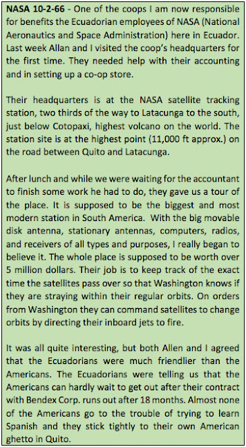
In August 1957, the United States, through NASA (the National Aeronautics and Space Administration) installed on the slopes of Cotopaxi Volcano, a Satellite Tracking Station for the purpose of monitoring and controlling the orbit of American satellites.  
 
NASA rocket on the launch pad


In 1981, fifteen years after our visit to the satellite tracking station, NASA ended 25 year’s of tracking US space satellites in Ecuador and handed the station over to the Ecuadorian government.
 
In 1977 Ecuador created CLIRSEN (the Center for Integrated Natural Resources Remote Sensing). Starting in 1981 CLIRSEN gathered satellite data to produce maps for the planning and development of the country. Subjects covered included agriculture, aquaculture, environment, health and disaster preparedness. 
 
In 2007 Ecuador celebrated the 50th anniversary of the station. Beginning in 2012, the station was operated by a new Ecuadorian agency; the Ecuadorian Space Institute or IEE. The Institute continued the activities developed under CLIRSEN and took on new responsibilities related to space research.
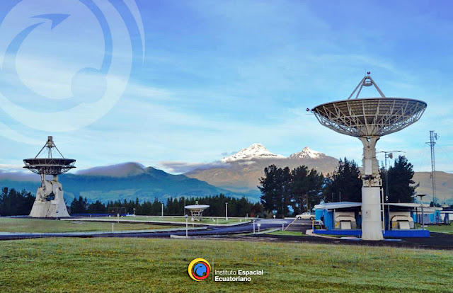
 

Image based on an official photo of the Ecuadorian Space Institute
operating on the site of the former satellite tracking station


Cooperative Courses


Creating and presenting various courses for the cooperatives under my responsibility was my first introduction to teaching. As can be seen in my letters home, I thoroughly enjoyed the teaching experience.
 
Students in one of our cooperative classes 


My language failings bothered me throughout my Peace Corps service. Despite this weakness, I seem to have survived and been of a benefit to the country. Working primarily in the capital city where English knowledge was highly valued and possessing skills learned from an excellent economics education helped me considerably.

Despite my lack of fluency with Spanish conversation, I was able to design and create the courses in Spanish. I used my Spanish knowledge to translate English sources into Spanish and present the information to the cooperative students. Reviewing the lessons learned, we found the students successfully expanding  their understanding of the particular subjects involved. 


Weather Ills


Quito's Plaza Grande (or de Independencia) before a winter rain

The weather is not the most exciting subject for a place located almost two miles high and on the equator. Nevertheless, it can have a significant impact on one's health if care is not taken to protect oneself.  
 
The proposed trip to Manta could have a positive health impact, especially since hurricanes are not known to frequent Manta's coast. Getting to better know the country we are serving in is also a positive benefit of service in the Peace Corps. Our Manta experience will be described in the next post.